
In earlier posts, I linked to maps that you can refer to if you want to trace my walking route visually. My purpose, in this post, is to give an overall view of the route by naming the certification centers, which I'm assuming, in most cases, will also double as my rest stops. What follows, then, is a list of those centers, with approximate distances between stops. This will allow you to see how, specifically, my work has been cut out for me. As I noted before, assume "Day 1" and "Leg 1" are synonymous terms. It's true that disaster may strike, and I may end up staying two nights in a town instead of only one, but for now, let's be optimistic. This post will also obviate the need for me to create a map for each leg. You can use the maps I've linked to, plus Naver Map, to see the route in greater detail.
Day 1:
My place to Paldang Bridge. Approximately 15.5 miles (25 km). My new, encumbered walking speed is probably around 2.8 miles per hour, at least at the outset. During my massive walk last night, I was able to maintain a decent speed without faltering as long as the ground was level. Probably camping here.
Approximate total distance walked: 15.5 miles/25 km.
Day 2:
Paldang Bridge to 양평군립미술관 자전거길 인증센터 (Yangpyeong-gun Museum of Art Bike Route Certification Center). Approximately 15.2 miles (24.4 km). This certification center seems to be in the midst of civilization, so I doubt I'll be camping here. (Naver shows yeogwans sitting about a kilometer south of the certification center.) Also of note: to get to this certification center, I'll first pass by the Paldang Dam/Neungnae Station certification center, but I won't be stopping there.
Approximate total distance walked: 30.7 miles/49.4 km.
Day 3:
Yangpyeong-gun Art Museum to Ipo Dam (Ipo-bo, 이포보), River House Inn (리버하우스 여관). Approximately 10 miles (16 km). The yeogwan (inn) sits about a mile south of the Ipo Dam, on the river's west side. I don't know yet how this works out in relation to the bike trail. There's another dam along the river called Yeoju-bo (bo means "dam"), but that would have been a monster of a walk.
Approximate total distance walked: 40.7 miles/65.5 km.
Day 4:
Ipo Dam, River House Inn to Yeoju-bo (여주보). Approximately 12 miles (20 km). Here again, plenty of civilization, so I'll likely be yeogwaning it. The certification center is located in town, so inns are not far off.
Approximate total distance walked: 52.7 miles/84.8 km.
Day 5:
Yeoju-bo past Gangcheon-bo to Binae-seom (Binae Island). Approximately 18.6 miles (30 km). This leg takes me past one certification center and up to another. It's a longer-than-usual walk, about as long as the walk I did on Friday night/Saturday morning. I'm seeing plenty of forest on the Naver Map satellite view, but no formal campground. I may just have to ask the permission of the natives to set my bivy sack up somewhere in the woods.
Approximate total distance walked: 71.3 miles/114.7 km.
Day 6:
Binae-seom to Chungju Tanggeumdae Certification Center (충주 탄금대 자전거길 인증센터). Approximately 15.6 miles (25 km). There's an inn called Baek Un Park (백운파크 여관) nearby. I'd say it was "walking distance," but given the scale of this walk, everything is walking distance to me. Heh.
Approximate total distance walked: 86.9 miles/139.9 km.
If I'm not mistaken, this takes me to the end of the Namhangang portion of the trail. Chungju Tanggeumdae (충주 탄금대) is the start the dreaded Saejae Trail which is, according to at least two different maps, 100 kilometers long. Since this is the trail that goes over the Baekdu Daegan range, I expect this to be at least 50 kilometers of hell for my fat self. Saejae also distinguishes itself by not following a major river.
Day 7:
Chungju Tanggeumdae to Suanbo Oncheon Certification Center (수안보온천 자전거길 인증센터). Approximately 17 miles (27.6 km). Oncheon means "hot spring" (you may know the Japanese term onsen). This once again takes me into a town, so I'll likely hit an inn. I should note, though, that if camping is possible in any of these places, I'd rather just camp. For one thing, if the foreign bikers are right, and camping is free, then I can stretch out and relax for the best price of all. For another thing, I much prefer to be outdoors instead of risking the skanky filthiness of a potentially nasty inn.
Approximate total distance walked: 103.9 miles/167.2 km.
Day 8:
Suanbo Oncheon to Ihwaryeong Rest Area Certification Center (이화령 휴게소 자전거길 인증센터). Approximately 9.4 miles (15.1 km). This looks to be a fairly short walk as the crow flies, but the contour lines that I cross don't look promising. (Yes, I discovered that, if you zoom in close enough, Naver Map does in fact have contour lines, which is very useful.) And with no facilities in the area, it appears I'll be camping.
Approximate total distance walked: 113.3 miles/182.3 km.
Day 9:
Ihwaryeong to Mungyeong Buljeong Station Certification Center (문경불정역 자전거길 인증센터). Approximately 11 miles (17.7 km). Another short-ish walk, but there don't appear to be any yeogwans or campgrounds. There's a minbak (something like a bed & breakfast—somewhat residential in feel, and less corporate and hotel-like) just north of the checkpoint: Gulmori Minbak (굴모리 민박), which might or might not have room for a traveler. This part of the country is a steep river valley, according to the contour lines, so I wouldn't be able to find a level spot on which to camp even if I wanted to. Here's what Gulmori Minbak looks like. If the place has room for me, I'll just stay there.
Approximate total distance walked: 124.3 miles/200 km.
Day 10:
Mungyeong Buljeong Station to Sangju Sangpunggyo Certification Center (상주상풍교 자전거길 인증센터). Approximately 18 miles (29 km). About a kilometer inland (to the west) from the water, there's a campground called Sangju Art Village Campground (상주예술촌캠핑장). I have a sinking feeling that it's not free, but it shouldn't be too expensive. My one fear is that I'll end up camping with some weirdo who wants to break through my introversion because he wants to talk, talk talk. Please, Jeebus, no.
Approximate total distance walked: 142.3 miles/229 km.
In theory, this marks the end, thank Cthulhu, of the Saejae Trail. From here until the end, I'll be following the Nakdong River Trail, whose full length is around 390 kilometers. However, I'll be picking up the trail about 30 km west of where it actually begins.
[The way I've mapped things, the Saejae Trail starts around the 140-km mark and ends at about the 230-km mark, which comes out to 90 kilometers. The various maps I've been referencing reckon that the trail is 100 kilometers long, so I imagine I'll be walking a bit more, per day, than what I've noted above. But on a per-day basis, the extra distance will be negligible when spread out over the length of the Saejae path.
Day 11:
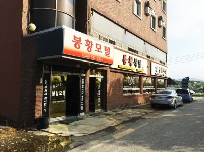
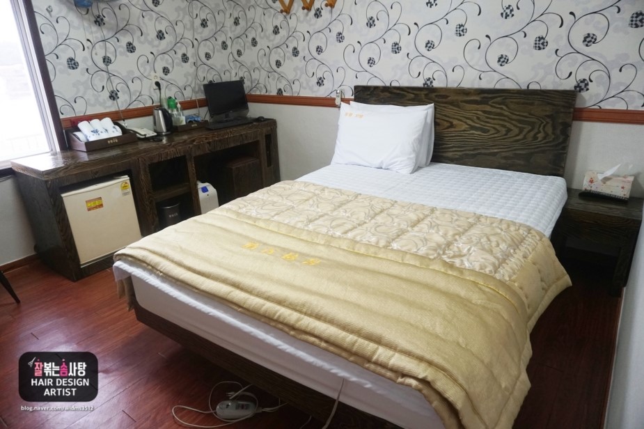
Sangju Sangpunggyo past Sangju-bo (Sangju Dam, 상주보) to Nakdan-bo Certification Center (낙단보 자전거길 인증센터). Approximately 16.6 miles (26.7 km). Across the river and a bit before the certification center, there's a hotel called the Bonghwang Hotel. I'll likely hit the certification center, stamp my book, then double back and hit that hotel, whose interior also looks fairly nice.
Approximate total distance walked: 158.9 miles/255.7 km.
Day 12:
Nakdan-bo to Gumi-bo Certification Center (구미보 자전거길 인증센터). Approximately 10.6 miles (17 km). I'm not seeing any hotels or inns, and there are no campgrounds. At the same time, there's plenty of green, so I could, in theory, locate a spot and not bother anyone, although it'd be prudent to ask someone first... assuming anyone's around to ask.
Approximate total distance walked: 169.5 miles/272.8 km.
Days 13-14:
Gumi-bo to Chilgok-bo Certification Center (칠곡보 자전거길 인증센터). Approximately 20.4 miles (32.8 km). Definitely yeogwans here. I see one called Riverside Jang Yeogwan (리버사이드장여관). I assume the jang comes from jang-so, i.e., a place: Riverside Place Inn, a thoroughly bland, nondescript name if ever there was one. This day's walk is going to take me eight hours, assuming I walk without stopping, but more likely nine or ten hours, assuming I do stop along the way. I'll be arriving at the inn around 4PM. What bothers me is that, after walking such a distance, I'll have much less time to recuperate than usual. However, as I look ahead on one of my maps, I see that, at the rate I'm walking, I ought to be done with the whole walk within twenty days. Since I'm anticipating taking 24-25 days, then this might be the perfect chance for me to spend two nights at this yeogwan, just a-resting my aching feet before subjecting them to abuse again. Despite our initial optimism, this may be where "day" and "leg" part company.
Approximate total distance walked: 189.9 miles/305.6 km.
Day 15, Leg 14:
Chilgok-bo to Gangjeong Goryeong-bo Certification Center (강정고령보 자전거길 인증센터). Approximately 17 miles (27 km). This puts me on the west end of Daegu, the city I lived near for a year (I was off to the east, in a little town called Hayang). I may have to walk into town to find a yeogwan, which will take me miles out of my way, or I might just plop down on a patch of ground by the river and hope no one disturbs me.
Approximate total distance walked: 206.9 miles/333 km.
Day 16, Leg 15:
Gangjeong Goryeong-bo to Dalseong-bo Certification Center (달성보 자전거길 인증센터). Approximately 14 miles (22.5 km). There's a "motel" a little ways off (about a mile, or 1.6 km) called the Sangnoksang-jang Motel (상록산장모텔); it'll be a bitch to walk there from the certification center, but it seems that I can reach the motel by continuing east-southeast on the bike path.
Approximate total distance walked: 220.9 miles/355.5 km.
Day 17, Leg 16:
Dalseong-bo to Hapcheonchangnyeong-bo Certification Center (합천창녕보 자전거길 인증센터). Approximately 17.8 miles (28.7 km). A nice, long walk. I see no inns nearby, so it looks as though I'll have to risk camping again. There's some sort of admin office not far from the stamp booth; I might go talk to some folks in that building to see what I can do.
Approximate total distance walked: 238.7 miles/384.2 km.
Days 18-19, Leg 17:
Hapcheonchangnyeong-bo to Changnyeonghamanbo Certification Center (창녕함안보 자전거길 인증센터). Approximately 25.7 miles (41.3 km). This promises to be a huge walk. My own personal record is thirty-some miles from Troutdale to Cascade Locks in the space of 24 hours. I suspect this will be another two-nighter at whatever place I settle down in, and from the satellite images, it looks as though I'll be camping yet again. As before, there's some sort of admin office near the stamp booth, so I might limp inside and ask some of the good folks within for advice on where to stay. If they have no advice to give, then camping it is!
Approximate total distance walked: 264.4 miles/425.5 km.
Days 20-21, Legs 18-19:
Changnyeonghamanbo toward Yangsan-si Certification Center (양산시 자전거길 인증센터). Approximately 25.5-30 miles (41-50 km). This is going to be too much to walk in a single day. Curiously, parts of the map (Naver Map version) are blurred out at the destination. I wonder why. I don't see exactly where the stamp booth is, either; the map is vague on this point, whereas it normally uses an "i" icon to identify the booth. Assuming the booth is where the map is vaguely pointing, there's a town, not far off, with a hotel called the "Ta-im Hotel" or "Time Hotel" (타임 호텔)—I'm not sure which romanization is correct here. I'll spend the night of Day 21 there. On Day 20, when I'm about halfway, I'll just flop down and camp wherever; I'm sure there'll be plenty of free patches of ground. It seems this trip is going to be yeogwan-heavy at the beginning, then camping-heavy toward the end.
Approximate total distance walked: 294.4 miles/473.8 km.
Day 22, Leg 20:
From Yangsan-si to the FINISH in Busan proper. Final leg. Approximately 18.6 miles (30 km). The goal is to reach the Nakdonggang Hagutduk (I've seen this spelled either 낙동강 하굿둑 or 낙동강 하구둑), or the Nakdong River's estuary, i.e., the point where the river meets the ocean. The trail ends by the water. If you've watched that Canadian biker's video, to which I linked long ago (here it is again), then, at the end of his video, you'll see the exact spot where I'll be ending my walk. Actually, I won't end it there: I'll walk to the water and touch the ocean, and that, friends, will be the end.
Approximate total distance walked: 313 miles/503.7 km.
I seem to be gathering some interest from people who might want to meet me at the very end of my journey, so there may be a welcoming party at that final red booth. I plan to spend the night in Busan to rest my feet, after which I'll take the KTX back to Seoul... unless someone in the welcoming party decides to give me a ride back.
If I do manage this feat in 22 days, it'll be a miracle. I completely expect the Murphy factor to creep in, probably in the form of rain leading to blisters leading to much slower walking. There could be other disasters waiting for me: my backpack, which is no longer new, could burst a stitch, snag a zipper, or lose a crucial strap; my water-purification system could fail me, thus exposing me to waterborne pathogens; I could end up with a dull ache that, after a hundred miles, has turned into an excruciating pain. Anything goes, but I'm hoping that preparation—along with wisdom gained from the previous walk in 2008—will prevent most of these Murphic occurrences and make for smooth sailing.
A note about the above-listed distances: there's reason to doubt their accuracy, so they should be thought of as very rough estimates. Many of the bikers whose videos I've watched claim to have ridden at or over 600 kilometers from Seoul to Busan. This could be because they started either in Incheon or at the west end of Seoul; it could also be that they followed a branch-off before turning around and following the main artery down to Busan. It could also simply be that everyone's maps measure things differently. The Canadian biker, mentioned earlier, claimed to have ridden 570-some kilometers, and he started his ride around Apgujeong, i.e., about dead-center in Seoul.
I've certainly noticed discrepancies with some of the dead-tree and online references that I've been using: one book lists the Nakdong River Trail as 386 km long; another says 389. Why the large difference? For a layman like me, this basically means that I have, at best, only a rough idea of the actual distances in question. No one source is entirely trustworthy, and I certainly can't rely on my pedometer to be accurate about distances (mainly because it uses inertial navigation, not GPS, to calculate distances*).
As a result, I have to be flexible in my estimates of time and distance—estimates that will change daily as I assess and reassess my physical condition. Except for parts of the Saejae trail, I don't think I'll find myself schlepping along at one mile per hour the way I did, at points, in 2008. With so much less weight on my back, I ought to be able to maintain a fairly decent pace: probably 2.8 miles per hour in the morning, and maybe slowing down to 2.1 miles per hour near the end of each day, i.e. early to mid-afternoon. I think, though, that if I'm good about starting before 6AM every day (wake up at 5AM, perform my ablutions, strike camp if I'm not in an inn), I'll always arrive at that day's destination with plenty of daylight to spare, and plenty of time to rest my weary feet. The rest will be vital if I hope to continue: I'm not a soldier conditioned to march 30 miles a day with 120 pounds on my back.
Assuming I walk about seven hours a day, that gives me about seventeen hours a day to rest my feet. After my walk on Friday night/Saturday morning, I did a self-assessment of how my feet felt after seventeen hours. Result: they were achy, but only vestigially. Resuming a walk the following morning, with feet that are only slightly achy, won't be a problem: any aches will fade within a thousand or so steps, especially once I slot into a decent pace.
So that's my route, leg by leg. I may be off by as much as 100-130 kilometers in my estimation of distance (Naver doesn't measure distance automatically along bike routes, although it does have a "bike route" button to allow you to see the routes... I may go back and use that function to measure routes manually), and this might add another few days to the walk, but even if I do walk a few extra days, I'll finish before my month's break is up.
One last note: years ago, a friend gave me a Moleskine notebook that I promptly put away and never looked at again. I'll be taking that book along with me, perhaps with a pen and/or pencil, and I'll be putting those certification-center stamps into the Moleskine instead of buying a "passport" that I don't need. I'll also be writing my route into the first twenty-some pages of the notebook—just to keep things straight in my head.
*Inertial navigation uses the phone's built-in accelerometers, along with algorithms that rely on trigonometry as well as certain programmed assumptions about things like stride length and the elimination of in-the-pocket jiggling from the calculation of distance. While my pedometer's step counter has proven to be fairly accurate, I've been given no reason to trust my phone's distance-measuring capabilities, which often strike me as way off.


This post left me exhausted!
ReplyDeleteBreaking it down like this really brings home the massive undertaking you have set for yourself. I'm glad I'll be with you. In spirit.
Thanks, I think.
ReplyDelete